Map of Asia Minor
Tidigare ett hettitiskt rike runt staden Hattusa.
En del av Kappadokien tillhörde storlandskapet Karamanien.
Under persiska riket var Katpatuka två hövdingedömen (ståthållardömen) (satrapier): Kappadokien vid Pontos samt det Inre eller Sydliga Kappadokien (även Stor-Kappadokien).
Namnet inskränktes sedermera till den södra delen, det Kappadokien som existerade under Alexander och Seleukidernas rike och självständigt kungarike, innan romarna tog över.
Invånarna kallades av Herodotos "vita syrier" (leukosyroi). På denna karta ligger Kappadokien precis norr om Kilikien. Men då det var som störst sträckte det sig alltså upp till kusten av Svarta Havet. Att det fanns fina hästar där kan tyda på släktskap med skyterna, som var kända för sina ridhästar. De red till strids istället för att låta hästarna dra stridsvagnar som varit brukligt bland de ledande folken innan dess. Hettiternas imperium med centrum i området (Hattusa) föll redan på 1200-talet före Kristus. Kimmererna och skytherna ankom 700-talet och framåt. Folktabellen i första Mosebok kapitel 10 skriven på 600-talet senast, kan man sluta sig till, eftersom mederna men inte perserna står med. Jafets söner: Gomer, Magog, Tuval Meshek - folk i Mindre Asien. Gomer i sin tur är ursprung till Ashkenas och Togarma. Kimmererna - Skytherna - Sarmaterna. Men vilka är Tuval och Meshek, ofta samskrivna med bindestreck. Och Gog i Magogs land, stor(rosh) furste över Meshek och Tuval ?

The Nations of Ezekiel 38 - 39
Who Will Participate in the Battle?
Who Will Participate in the Battle?
Map of Asia Minor in New Testament Times

Från neolithikum utgjorde Mindre Asien vägen för kulturströmningen från Främre Asien till Europa. Under 4000-talet nådde jordbruket Greklands och Kretas kuster och därifrån nådde det Balkanområdet och sedan hela Europa.
Bronshanteringen förmedlades genom kulturerna på den Anatoliska halvön.[1]
Från 1400-talet fKr är hettiterna kända för att ha smält järn av skör (brittle) kvalitet och den nya metallen infördes i Grekland.[2]
De indoeuropeiska hettiterna kom till området under 20e århundradet fKr. De grundade ett stort imperium som förstördes av inkräktare (omdebatterat, det ska ha fallit sönder pga inbördes stridigheter inte minst inom kungafamiljen!) Grekisktalande befolkningar flyttade (därifrån) och grundade städerpå västkusten upp till Svarta havet.
Under 500-talet fKr utvidgades kungariket Lydien och täckte nästan hela Mindre Asien, tills det blev ett ståthållardöme (satrapy) under Persien. Efter grekpersiska krigen, 400-t fKr, ingick kuststäderna i det ganska tillfälliga Deliska Förbundet (Delian League) [3]
Och på 300-talet erövrade Alexander den store halvön och besegrade perserna. Efter honom förföll hans imperium och Mindre Asien styrdes av en rad hellenistiska kungadömen, t ex Kungadömet Pontus från 200-talet till någon gång runt 50 f Kr. Under vilken tid romarna hade tagit över.
Mindre Asien var den region där ett mytiskt sätt att tänka utvecklades till ett rationellt. "Det verkar som att grekerna drog fördel av att observera några av de äldre civilisationerna och lyckades "work them up" tolka och omarbeta dem? förnuftsmässigt. [4] Exempelvis föddes i detta område den första västerländska litteraturen (bl a den Hurriansk–Hettitiska), den Antika grekiska filosofins huvudskolor, och den första polis.
Många religiösa element, bland annat orakelkulten kom från hettiterna till grekerna. Romarna hade också detta - sibyllorna.[5] The Joniska skolan var de första naturfilosoferna som försökte förklara fenomen utan att åberopa det övernaturliga. Pythagoras införde abstrakta matematiska relationer, grunden för den matematiska vetenskapen. Sammanfogade argument utifrån assumerade eller accepterade utgångspunkter.
Deliska förbundet - tyvärr en karta där texten blivit bortblurrad.
Eastern Anatolia contains the oldest monumental structures in the world. For example, the monumental structures at Göbekli Tepe were built by hunters and gatherers a thousand years before the development of agriculture. Eastern Anatolia is also a heart region for the Neolithic revolution, one of the earliest areas in which humans domesticated plants and animals. Neolithic sites such as Çatalhöyük, Çayönü, Nevali Cori and Hacilar represent the world's oldest known agricultural villages.
The earliest historical records of Anatolia are from the Akkadian Empire under Sargon in the 24th century BC. The region was famous for exporting various raw materials.[14] The Assyrian Empire claimed the resources, notably silver. One of the numerous Assyrian cuneiform records found in Anatolia at Kanesh uses an advanced system of trading computations and credit lines.[14]
Unlike the Akkadians and the Assyrians, whose Anatolian possessions were peripheral to their core lands in Mesopotamia, the Hittites were centred at Hattusa in north-central Anatolia. They were speakers of an Indo-European language known as the "language of Nesa". Originating from Nesa, they conquered Hattusa in the 18th century BC, imposing themselves over a Hurrian speaking population. During the Late Bronze Age, they created an empire, the Hittite New Kingdom, which reached its height in the 14th century BC. The empire included a large part of Anatolia, north-western Syria and upper Mesopotamia. After 1180 BC, the empire disintegrated into several independent "Neo-Hittite" states. Ancient Anatolia is subdivided by modern scholars into various regions named after the people that occupied them, such as Lydia, Lycia, Caria, Mysia, Bithynia, Phrygia, Galatia, Lycaonia, Pisidia, Paphlagonia, Cilicia, and Cappadocia.
Beginning with the Bronze Age Collapse at the end of the 2nd millennium BC, the west coast of Anatolia was settled by Ionian Greeks. Over several centuries, numerous Ancient Greek city states were established on the coasts of Anatolia. Greeks started Western philosophy on the western coast of Anatolia (Pre-Socratic philosophy). In the 6th century BC, most of Anatolia was conquered by the Achaemenid Empire. In the 4th century BC, Alexander the Great conquered the peninsula. Following his death and the breakup of his empire, Anatolia was ruled by a series of Hellenistic kingdoms. Two hundred years later western and central Anatolia came under Roman control, but it continued to be strongly influenced by Hellenistic culture.[15] In the 1st century BC, the Armenians established the Armenian kingdom under Tigran who reigned throughout much of eastern Anatolia between the Caspian, Black and Mediterranean seas. Anatolia is known as the birthplace of coinage as a medium of exchange (some time in the 7th century BC), which flourished during the Greek and Roman eras.[16][17]
Tidigast attesterade namnet är den hettitiska Assuwa - en region i centrala Västanatolien som kan knytas till det Mykensk grekiska epitetet "a-si-wi-ja" i Linear B inskriptioner från Pylos. 
Eastern Anatolia contains the oldest monumental structures in the world. For example, the monumental structures at Göbekli Tepe were built by hunters and gatherers a thousand years before the development of agriculture. Eastern Anatolia is also a heart region for the Neolithic revolution, one of the earliest areas in which humans domesticated plants and animals. Neolithic sites such as Çatalhöyük, Çayönü, Nevali Cori and Hacilar represent the world's oldest known agricultural villages.
The earliest historical records of Anatolia are from the Akkadian Empire under Sargon in the 24th century BC. The region was famous for exporting various raw materials.[14] The Assyrian Empire claimed the resources, notably silver. One of the numerous Assyrian cuneiform records found in Anatolia at Kanesh uses an advanced system of trading computations and credit lines.[14]
Unlike the Akkadians and the Assyrians, whose Anatolian possessions were peripheral to their core lands in Mesopotamia, the Hittites were centred at Hattusa in north-central Anatolia. They were speakers of an Indo-European language known as the "language of Nesa". Originating from Nesa, they conquered Hattusa in the 18th century BC, imposing themselves over a Hurrian speaking population. During the Late Bronze Age, they created an empire, the Hittite New Kingdom, which reached its height in the 14th century BC. The empire included a large part of Anatolia, north-western Syria and upper Mesopotamia. After 1180 BC, the empire disintegrated into several independent "Neo-Hittite" states. Ancient Anatolia is subdivided by modern scholars into various regions named after the people that occupied them, such as Lydia, Lycia, Caria, Mysia, Bithynia, Phrygia, Galatia, Lycaonia, Pisidia, Paphlagonia, Cilicia, and Cappadocia.
Beginning with the Bronze Age Collapse at the end of the 2nd millennium BC, the west coast of Anatolia was settled by Ionian Greeks. Over several centuries, numerous Ancient Greek city states were established on the coasts of Anatolia. Greeks started Western philosophy on the western coast of Anatolia (Pre-Socratic philosophy). In the 6th century BC, most of Anatolia was conquered by the Achaemenid Empire. In the 4th century BC, Alexander the Great conquered the peninsula. Following his death and the breakup of his empire, Anatolia was ruled by a series of Hellenistic kingdoms. Two hundred years later western and central Anatolia came under Roman control, but it continued to be strongly influenced by Hellenistic culture.[15] In the 1st century BC, the Armenians established the Armenian kingdom under Tigran who reigned throughout much of eastern Anatolia between the Caspian, Black and Mediterranean seas. Anatolia is known as the birthplace of coinage as a medium of exchange (some time in the 7th century BC), which flourished during the Greek and Roman eras.[16][17]
Assuwaförbundet (Assuwa league), asen statskonfederation i Västanatolien inbegrep en vid räcka av mindre anti-hettitiska makter.
Grekerna beskriver först Assuwa som en slätt nära Kaysterfloden (Homeros). Asien var för grekerna först det centrala Västanatolien. Deras mytologi gav namnet Asia till en lydisk kvinnlig titan. När romarna tog över fick hela halvön namnet Asia. Inte förrän på 400-talet eKr fick det namnet Asia Minor av den latinske författaren Konstantinos Porphyrogennetos. Bysantinska imperiets Macedoniska dynastis fjärde kejsare på 800-talet kallade Asia Minor "Östra thema" "ανατολικόν θέμα" (grekiska anatoli: öst, thema: administrativ uppdelning),[10] då den låg öster om Bysans, medan Europa låg till väster.
Turkarna översatte till Anadolu, som har blivit Anatolien.
Europeiska sjömän och handelsmän kallade området Levanten i vilket de inbegrep Syrien. Lévante kommer från franska verbet lever - att höja, stiga upp, dvs landet där solen stiger.
Nu till folken och städerna som nämns i Hesekiels 38 kapitel: Gog, Magog, Rosh, Meshech, Tubal, Gomer och Togarma. Bibelns hebreiska skrevs med konsonanter uteslutande.
Togarma: TLGRM, assyriska källor "Tilgarimmu" eller Tigarimmu- en polis (stadsstat) i östra Anatolien, sydöstra Turkiet, nära syriska gränsen.
Som extravetande kan nämnas att Robert Spencer, redaktör för Jihadwatch, har utgivit boken The Islamic Antichrist - the shocking truth about the nature of the Beast - han menar att Tigarimmu är namnet på Odjuret, som då enligt honom skulle komma från islam.
Gomer GMR var under antiken känt som Gimarrai, i norra Mindre Asien, Kappadokien. Kimmererna.
Rosh RŠ betyder egentligen "huvud" och "hövding". Det har inte funnits någon plats med namnet Rosh. Översättningen ska vara: "storhövding (chief prince) av Meshech och Tubal." som i King James Version, Targum, Aquila och Vulgata.
Meshech MŠK Mushkierna i västra och centrala Mindre Asien, känt som Phrygien ?? som existerade på Hesekiels tid och omskrivna av grekiska klassiker, bl a Homeros. Varifrån kommer då Mysien? Det visar sig vid närmare efterforskning att myserna var släkt med frygerna och lydierna och de talade liknande språk.
Tubal (TBL) staden Tabal i östra Mindre Asien. (Gimarri = Gomer, och Mushki = Meshek, i centrala Mindre Asien.
Tabal (Bib. Tubal) ett neo-hettitiskt (efter-hettitiskt?) luwisk-talande (Luwian) kungarike i södra centrala Anatolien. Arkeologen Kurt Bittel hävdar att kungariket Tabal uppstod först efter att hettiterriket kollapsat.
Assyriske konungen Shalmaneser III förde till källorna att han mottagit gåvor från sina 24 lydkonungar år 837 och 836 f Kr.
100 år därefter nämns Tabals kung Burutush i en inskrift av kung Tiglath-Pileser III.
Tabals kungar efterlämnade ett antal inskriptioner från 800-700-talen f Kr, luwiska hieroglyfer i de turkiska byarna Çalapverdi och Alişar.
Tabal och dess folk identifieras ofta med stammen Tibarenierna(Tibarenoi (grek) Thobeles hos Josephus. Dessa levde nära Svarta havet. De nämns av Hecataeus, Herodotus, Xenophon och Strabon. Pga detta ansåg den georgiske historikern Ivane Javakhishvili att Tabal, Tubal, Jabal and Jubal var antika georgiska stambeteckningar och att folken talade indo-europeiska språk. to be ancient Georgian tribal designations, and argued that they spoke a non-Indo-European language. Förblir osäkert om det verkligen fanns en koppling mellan tibarenerna vid Svarta havet och kungadömet Tabal i södra Anatolien. Kanske blandades de ihop redan under Antiken.
Kända härskare i Tabal: Ambaris till cirka 713, Hidi ca 690, Mugallu ca 670, x-ussi ca 650.
Gog - somliga har identifierat honom med
1. Gyges, konung i Lydien som låg långt västerut i Mindre Asien (600-talet f Kr)och kallas
Gugu i Ashurbanipals texter.
2. platsnamnet Gagai som noterats i Tell el Amarna-breven som ett barbarland..
3. En gud vid namn Gaga i skrifterna från Ras Shamra.
4. Gagu, furste över landet Sakhi, norr om Assyrien.
5.Gaga, en bergsregion norr om Meletene.
6. Eller identifierat honom med Alexander den store.
7.Gog skulle kunna vara en officiell titel eller beteckning för fiende till Guds folk. En tolkning grundad på Septuagintas återgivning av kungliga namn i Gamla testamentet.
8. Ett derivat av det besläktade Magog. .
Josefus: "Magog gav upphov till dessa som efter honom kallades magogiter, men som grekerna kallar skyther" dessa levde norr och nordost om Svarta havet. Först - sedan vandrade de söderut längs Svarta havets västkust. Nåt annat finns inte skrivet om Magog, utöver Bibelns utsagor. Man appellerar till grammatikern och lexicografen Gesenius, när denne fått sina uppgifter från Josephus.
Dessutom är i historisk antropologi skytherna ättlingar av Gomer genom Ashkenas - detta stämmer inte med Magog.
Bibeln ger en ledtråd om Magogs allmänna grannskap: "Gog" är ett anatoliskt namn. Om Meshech och Tubal identifierats korrekt som boende i Mindre Asien, borde Magog också vara en del av Mindre Asien, eftersom Meshech och Tubal levde i området Magog. Hesekiel 38:2. Eftersom Gog skulle komma från "landet längst uppe i norr" Hes 38:15, För Hesekiel var Mindre Asien eller området norr om Svarta havet den nordliga kanten på jorden.
Men i Hes 38:6 sägs det att också Togarma låg längst uppe i norr - och detta var alltså stadsstaten Tilgarimmu i östra Mindre Asien.
Bibeln skriver om Gog i Magogs land, storfursten över Tubal och Meshek. Det handlar om en kung som regerade i området (regionen) Magog över statsstaten Tigarimmu (Togarma) i sydöstra Turkiet vid gränsen till Syrien. Och över mushkierna, folket i Phrygien - längre västerut, centrala Mindre Asien. Eftersom folktabellen i Genesis 10 skrevs på 600-talet, räknar jag med att de geografiska beteckningarna hör hemma i det århundradet. Frågan är då hur stort Magog-regionen var - från syriska gränsen västerut, men hur långt? De västliga mushkierna bodde just på 700-600 talen i Kappadokien och Kilikien. De östliga kan man lämna därhän eftersom noteringarna om dessa ligger ett par hundra år tidigare. Österut från Kappadokien låg Assyriska kärnlandet mellan Eufrat och Tigris i vad som nu är östra Turkiet och Irak. Så vad kan Magog-regionen då vara om inte samma område som en gång hettiter-riket och sedermera Kappadokien? Kilikien hade en gång haft namnet Kizzuwadna. Men exakt var kan man lokalisera mushkierna (Meshek)?
Frygien (Phrygia) Kursiverade orter är grekiska.

Politisk karta över Anatoliska halvön 500 före Kristus.
==============
The Mushki (Muški; Georgian: მესხები Meshebi, Meskhetians, Moschia) ett järnåldersfolk i Anatolien i assyriska källor. Finns dock inte i Hettitiska uppteckningar. Moschoi (Μόσχοι) i grekiska urkunder och den georgiska stammen Meskhi.
Josephus Flavius identifierade Moschoi med Bibelns Meshech.
Två grupper i assyriska källor kallas Muški. De östliga Mushki från 1100-800talen f Kr och som bodde där floderna Arsanias och Eufrat flöt samman (confluence). Västra Mushki 700-600-talen i Kappadokien and Kilikien.
Assyriska källorna identifierar de västra mushkerna med Phrygierna, men grekiska urkunder skiljer klart mellan frygierna och Moschoi.
.
Identification av östra med västra Mushkerna är osäkert - men en del kan ju ha flyttat iväg. Fast det skiljer en tidrymd på ett par hundra år. Man har gissat att de talade georkiskt eller armeniskt eller anatoliskt språk. Encyclopedia of Indo-European Culture : enligt Diakonoff är Armenierna ett amalgam av Hurrian (and Urartians), Luvians and the Proto-Armenian Mushki (eller Armeno-Phrygians) som förde sitt indo-europeiska språk österut genom Anatolien" Var det inte västerut?
Contents[show] |
Östra mushkierna och olika Havsfolk (Sea peoples) tycks ha flyttat in i Hatti på 1100-talet f Kr när hettiterriket var på väg att kollapsa. De etablerade sig i ett post-hettitiskt kungarike i Kappadokien. Historiker träter om ifall de kom från öster eller väster. Några tror att de ursprungligen ockuperade ett område i området Urartu. Antika berättelser ger vid handen att de kom från ett västligt hemland, en del av den Armeno-Phrygiska vandringen, från trakten av Troja, kanske så långt ifrån som Makedonien, som Brygerna.
Med Hurrierna och Kaskas, invaderade de de assyriska provinserna Alzi och Puruhuzzi omkring 1160 fKr. De slogs tillbaka och besegrades jämte Kaskerna av Tiglath-Pileser I år 1115 fKr, som till år 1110 hade nått till Milid.
Västra mushkierna: på 700-talet blev Tabal (bibelns Tubal / Tuval) den starkaste efter-hettitiska stadsstaten (polis). Mushkierna under Mita ingick en anti-assyrisk allians med detta Tabal och med Karchemish. Alliansen slogs ner av assyriernas kung Sargon., Denne intog Karkemish och drev tillbaka Mita till hans egen provins.
Ambaris av Tabal (Tubal) var gift med en assyrisk princessa och mottog provinsen Hilakku, men år 713 fKr, avsattes Ambaris och Tabal blev en assyrisk provins.
In 709, the Mushki re-emerged as allies of Assyria, Sargon naming Mita as his friend. It appears that Mita had captured and handed over to the Assyrians emissaries of Urikki, king of Que, who were sent to negotiate an anti-Assyrian contract with Urartu, as they passed through his territory.
According to Assyrian military intelligence reports to Sargon recorded on clay tablets found in the Royal Archives of Nineveh by Sir Henry Layard, the Cimmerians invaded Urartu from Mannai[3][4] in 714. From there they turned west along the coast of the Black Sea as far as Sinope, and then headed south towards Tabal, in 705 defeating an Assyrian army in central Anatolia, resulting in the death of Sargon. Macqueen (1986:157) and others have speculated that the Mushki under Mita may have participated in the Assyrian campaign and were forced to flee to western Anatolia, disappearing from Assyrian accounts, but entering the periphery of Greek historiography as king Midas of Phrygia.
Rusas II of Urartu in the 7th century fought the Mushki-ni to his west, before he entered an alliance with them against Assyria.
[edit] Moschoi

According to Herodotus, the equipment of the Moschoi was similar to that of the Tibareni, Macrones, Mossynoeci and Mardae, with wooden caps upon their heads, and shields and small spears, on which long points were set. All these tribes formed the 19th satrapy of the Achaemenid empire, extending along the southeast of the Euxine, or the Black Sea, and bounded on the south by the lofty chain of the Armenian mountains.
Strabo locates the Moschoi in two places. The first location is somewhere in modern Abkhazia (Georgia) on the eastern shore of the Black Sea, in agreement with Stephan of Byzantium quoting Hellanicus. The second location Moschice (Moschikê) – in which was a temple of Leucothea, once famous for its wealth, but plundered by Pharnaces and Mithridates – was divided between the Colchians, Armenians, and Iberians (cf. Mela, III. 5.4; Pliny VI.4.). These latter Moschoi were obviously the Georgian Meskhi or Mesx’i (where Greek χ, chi, is Georgian ხ, x). Procopius calls them Meschoi and says that they were subject to the Iberians (i.e., Georgians), and had embraced Christianity, the religion of their masters. According to Professor James R. Russell of Harvard University, the Georgian designation for Armenians Somekhi, preserves the old name of the Mushki.
Pliny in the 1st century AD mentions the Moscheni in southern Armenia ("Armenia" at the time stretching south and west to the Mediterranean, bordering on Cappadocia). In Byzantine historiography, Moschoi was a name equivalent to or considered as the ancestors of "Cappadocians" (Eusebius) with their capital at Mazaca (later Caesarea Mazaca, modern Kayseri).
[edit] Biblical Meshech
Main article: Meshech

[edit] Mtskhetos and Mtskheta
The ancient city of Mtskheta, near Tbilisi, is believed by Georgian experts to be the former capital of the Mushki state. According to the medieval Georgian Chronicles, the city was built by the legendary patriarch Mtskhetos, one of five sons of Kartlos, the legendary patriarch of the Georgian nation (who was in turn said to be a son of Torgom, the Georgian spelling of Biblical Togar Mah, son of Gomer, son of Japheth, son of Noah). According to the Chronicles, during Mtskhetos' lifetime the descendants of Torgom (including Georgians, Armenians and other South Caucasian nations) were united and successfully resisted the attacks of the "Nimrodians", which Georgian experts interpret as a reference to ancient conflict between the Mushki and Assyria. Excavations in Mtskheta have confirmed the town dates back at least as far as 1000 BC.The Chronicles, the older Conversion of Kartli, and the older still Armenian chronicles of Moses of Chorene all give conflicting accounts of Mtskheta's history prior to and during the conquests of Alexander the Great. According to the Conversion, Mtskheta remained the chief city of "Kartli", the medieval native name for Georgia, up until Alexander's arrival, who changed the ruling dynasty in Mtskheta by installing Azo, said to be a prince from Arian Kartli. According to the Chronicles, after Mtskhetos' death, Kartli broke up into several smaller, warring regions, until unity was restored by Azo, said to be one of Alexander's Macedonian generals, who was in turn expelled by the (half-Persian) local prince Parnawaz, and it was Parnawaz who founded the new ruling dynasty of Kartli. Moses of Chorene says that Alexander installed a Persian satrap named Mithridates in Mtskheta.
While Georgian experts disagree over the details of their interpretations of these accounts, they generally agree that they reflect a decline of the Mushki state and rise of Persian influence before the arrival of Alexander, who, perhaps more as a side-effect than by any effort on his part, ushered in a new era of unity in much of the Mushki state's former territories under a new dynasty, who preferred the name Kartli over Mushki. Mtskheta remained the capital of the Kartli state, which became known in most languages as Iberia, until the 5th century AD.
[edit] Meskheti and the Meskhs
People in what is now a south-central Georgian region continued to favor a variant of the old Mushki name, and today call themselves Meskhs and their region Meskheti. They speak a dialect of Georgian called Meskhuri, which among Georgia's regional dialects is relatively close to official Georgian. The town of Mtskheta is not in today's Meskheti region, but lies about 100 km to its northeast, in the Kartli region.[edit] Massagetae
Georgian historians believe the Massagetae is another name for the Mushki, in contradiction to prevailing opinion which places the Massagetae in Central Asia. They base their argument on statements by Herodotus that the Massagetae lived "beyond the Araxes" (1.201) and that "after crossing the Araxes, Cyrus was sleeping on the territory of the Massagetae" (1.209), while rejecting as a mistake a third statement by Herodotus that "on the west the Caspian is bounded by the Caucasus; eastwards lies an immense tract of flat country ... the greater part of this region is occupied by the Massagetae" (1.204). Georgian historians also point to the similarity of the names Massagetae, Mtskheta and Meskheti, and to the lack of archeological evidence for a Massagetae state in Central Asia.[edit] Notes
- ^ identification with the Kaskas was tentatively suggested by Goetze (Diakonoff 1984:116)
- ^ “Armenians” in Encyclopedia of Indo-European Culture or EIEC, edited by J. P. Mallory and Douglas Q. Adams, published in 1997 by Fitzroy Dearborn.
- ^ Cozzoli, Umberto (1968). I Cimmeri. Rome Italy: Arti Grafiche Citta di Castello (Roma). http://openlibrary.org/b/OL19361902M/Cimmeri..
- ^ Salvini, Mirjo (1984). Tra lo Zagros e l'Urmia: richerche storiche ed archeologiche nell'Azerbaigian iraniano. Rome Italy: Ed. Dell'Ateneo (Roma). http://openlibrary.org/b/OL13958629M/Tra-lo-Zagros-e-l%27Urmia.
- ^ Fragmenta historicorum graecorum I, fragm. 228.
[edit] See also
The Chalybes or Chaldoi (Χάλυβες, Χάλυβοι, Χάλδοι) were a tribe of proto-Georgians. Classical Antiquity credited with the invention of ferrous metallurgy.
They settled in north Anatolia known as Chaldia near the shores of the Black Sea, from the Halys to Pharnakeia and Trabzon in the east and as far south as Eastern Anatolia.
The main sources for the history of the Chaldoi are accounts from classical authors, including Homer, Strabo, and Xenophon. The Chaldoi/Chalybes, Mossynoikoi, and Tubal/Tabal/Tibareni, are counted among the first ironsmith nations by classical authors.[1] In Roman times, the Chaldaei (homonymous but unrelated to the Semitic Chaldeans) and Chalybes are mentioned by Plutarch (Lucull. c. 14) as settling in Pontic Cappadocia, or the Pontus Cappadocicus section of the Roman province of Pontus.
Χάλυψ, the tribe's name in Greek, means "tempered iron, steel", a term that passed into Latin as chalybs, "steel". Sayce derived the Greek name Chalybe from Hittite Khaly-wa, "land of Halys"[2].
URARTU - riket etablerades 860 och bestod till 590 före Kristus.
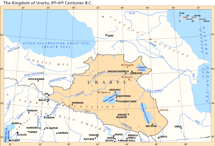
Urartus sydvästra del gick utmed Tigris och i väster nådde det fram till Eufrat. Det låg norr om Tauriska bergen - söder om dem låg det Assyriska väldet. De tre stora sjöarna i vad som nu är östra Turkiet var belägna inom Urartu liksom Noas berg Ararat. Ninive, assyriernas huvudstad, låg ett stycke söderut från Urartu. Detta rike låg där nuvarande Turkiet är helt omgivet av länder, inte hav. Österut sträckte det sig inte så långt som till Kaspiska havet.
Urartu (māt Urarṭu (assyriska) och Urashtu (babylonska) riket Ararat eller kungariket Van. På urartiska: Biai, Biainili. Rike som under järnåldern låg runt Vansjön i Armeniska höglandet.
Urartu är den assyriska beteckningen på det geografiska området. Kungariket Urartu eller Biainili-landen används av moderna historiker för att beteckna järnåldersstaten som uppstod i detta område, Armeniska Högländerna, bergsplatån mellan Mindre Asien, Mesopotamien och Kaukasus-bergen.
[edit] References
[edit] Bibliography
- Giorgi Leon Kavtaradze: Probleme der historischen Geographie Anatoliens und Transkaukasiens im ersten Jahrtausend v. Chr., in: Orbis Terrarum 2 (1996) S. 191-216 [1].
- Дэвид Лэнг (David Marshall Lang): Грузины. Хранители святынь, Москва. Центрполиграф, 2006. pp. 71–72
[edit] See also
Namnet Urartu: kung Shalmaneser I av Assyrien (1263–1234 BC) lät nedteckna en kampanj där han lade under sig hela territoriet "Uruatri". Källorna benämner åtta "länder" inom Urartu. Invånarna kallade kungariket för Biainili, även Biaineli - från vilket namnet Van kommer. Bian ----> Vian- . Före 700-talet f Kr kallade de också sin stat för Nairi. Forskarna menar att Urartu är en akkadisk variant på Ararat. Jeremia 51:27, nämner Ararat vid sidan av Minni och Ashkenaz.
Lehmann-Haupt ansåg 1910 att urartierna kallade sig khaldinier efter sin gud Khaldi. Se också folket khaldi. Nairierna var ett järnåldersfolk i Van-området och anses besläktade eller identiska.
Tidigt på 500-talet (590 f Kr) ersattes kungariket Urartu av den armeniska Orontid-dynastin. Den trespråkiga Behistun inscriptionen från 521/520 fKr beordrad av Dareios den store, Persien, referrerar till Urartu på assyriska, Arminiya på gammalpersiska och Harminuia på Harminuia på Elamitiska. I konfederationen Urartu fanns senare ett distrikt kallat Arme eller Urme som man förknippar med namnet Armenien.

 Urartu in 743 BC

Urartu comprised an area of approximately 200,000 square miles (520,000 km2), reaching from the river Kura in the north, to the northern foothills of the Taurus Mountains in the south; and from the Euphrates in the west to the Caspian sea in the east.
Enligt kartorna når det inte alls fram till Kaspiska havet.
At its apogee, Urartu stretched from the borders of northern Mesopotamia to the southern Caucasus, including present-day Armenia and southern Georgia as far as the river Kura. Archaeological sites within its boundaries include Altintepe, Toprakkale, Patnos and Cavustepe. Urartu fortresses included Erebuni (present day Yerevan city), Van Fortress, Argishtihinili, Anzaf, Cavustepe and Başkale, as well as Teishebaini (Karmir Blur, Red Mound) and others.
Discovery
Inspired by the writings of the medieval Armenian historian Movses Khorenatsi (who had described Urartian works in Van and attributed them to the legendary queen Semiramis), the French scholar Jean Saint-Martin suggested that his government send Friedrich Eduard Schulz, a German professor, to the Van area in 1827 on behalf of the French Oriental Society.[16] Schulz discovered and copied numerous cuneiform inscriptions, partly in Assyrian and partly in a hitherto unknown language. Schulz also re-discovered the Kelishin stele, bearing an Assyrian-Urartian bilingual inscription, located on the Kelishin pass on the current Iraqi-Iranian border. A summary account of his initial discoveries was published in 1828. Schulz and four of his servants were murdered by Kurds in 1829 near Başkale. His notes were later recovered and published in Paris in 1840. In 1828, the British Assyriologist Henry Creswicke Rawlinson had attempted to copy the inscription on the Kelishin stele, but failed because of the ice on the stele's front side. The German scholar R. Rosch made a similar attempt a few years later, but he and his party were attacked and killed.
In the late 1840s Sir Austen Henry Layard examined and described the Urartian rock-cut tombs of Van Castle, including the Argishti chamber. From the 1870s, local residents began to plunder the Toprakkale ruins, selling its artefacts to European collections. In the 1880s this site underwent a poorly-executed excavation organised by Hormuzd Rassam on behalf of the British Museum. Almost nothing was properly documented.
The first systematic collection of Urartian inscriptions, and thus the beginning of Urartology as a specialized field dates to the 1870s, with the campaign of Sir Archibald Henry Sayce. The German engineer Karl Sester, discoverer of Mount Nemrut, collected more inscriptions in 1890/1.

Waldemar Belck visited the area in 1891, discovering the Rusa stele. A further expedition planned for 1893 was prevented by Turkish-Armenian hostilities. Belck together with Lehmann-Haupt visited the area again in 1898/9, excavating Toprakkale. On this expedition, Belck reached the Kelishin stele, but he was attacked by Kurds and barely escaped with his life. Belck and Lehmann-Haupt reached the stele again in a second attempt, but were again prevented from copying the inscription by weather conditions. After another assault on Belck provoked the diplomatic intervention of Wilhelm II, Sultan Abdul Hamid II, agreed to pay Belck a sum of 80,000 gold marks in reparation. During World War I, the Lake Van region briefly fell under Russian control. In 1916, the Russian scholars Nikolay Yakovlevich Marr and Iosif Abgarovich Orbeli, excavating at the Van fortress, uncovered a four-faced stele carrying the annals of Sarduri II. In 1939 Boris Borisovich Piotrovsky excavated Karmir-Blur, discovering Teišebai, the city of the god of war, Teišeba. In 1938–40, excavations by the American scholars Kirsopp and Silva Lake were cut short by World War II, and most of their finds and field records were lost when a German submarine torpedoed their ship, the SS Athenia. Their surviving documents were published by Manfred Korfmann in 1977.
A new phase of excavations began after the war. Excavations were at first restricted to Soviet Armenia. The fortress of Karmir Blur, dating from the reign of Rusa II, was excavated by a team headed by Boris Piotrovsky, and for the first time the excavators of a Urartian site published their findings systematically. Beginning in 1956 Charles Burney identified and sketch-surveyed many Urartian sites in the Lake Van area and, from 1959, a Turkish expedition under Tahsin Özgüç excavated Altintepe and Arif Erzen.
In the late-1960s, Urartian sites in northwest Iran were excavated. In 1976, an Italian team led by Mirjo Salvini finally reached the Kelishin stele, accompanied by a heavy military escort. The Gulf War then closed these sites to archaeological research. Oktay Belli resumed excavation of Urartian sites on Turkish territory: in 1989 Ayanis, a 7th c. BC fortress built by Rusas II of Urartu, was discovered 35 km north of Van. In spite of excavations, only a third to a half of the 300 known Urartian sites in Turkey, Iran, Iraq, and Armenia have been examined by archaeologists (Wartke 1993). Without protection, many sites have been plundered by local residents searching for treasure and other saleable antiquities.
History
Origins

Assyrian inscriptions of Shalmaneser I (ca. 1274 BC) first mention Uruartri as one of the states of Nairi – a loose confederation of small kingdoms and tribal states in Armenian Highland in the 13th – 11th centuries BC which he conquered. Uruartri itself was in the region around Lake Van. The Nairi states were repeatedly subjected to further attacks and invasions by the Assyrians, especially under Tukulti-Ninurta I (ca. 1240 BC), Tiglath-Pileser I (ca. 1100 BC), Ashur-bel-kala (ca. 1070 BC), Adad-nirari II (ca. 900), Tukulti-Ninurta II (ca. 890), and Ashurnasirpal II (883–859 BC).
Urartu re-emerged in Assyrian inscriptions in the 9th c. BC as a powerful northern rival of Assyria. The Nairi states and tribes became a unified kingdom under king Aramu (ca. 860–843 BC), whose capital at Arzashkun was captured by the Assyrians under Shalmaneser III. Roughly contemporaries of the Uruartri, living just to the west along the southern shore of the Black Sea, were the Kaskas known from Hittite sources.
Growth

Fragment of a bronze helmet from Argishti I's era. The "tree of life", popular among the ancient societies, is depicted. The helmet was discovered during the excavations of the fortress Of Teyshebaini on Karmir-Blur (Red Hill).

Sarduri I (ca. 832–820 BC), son of Lutipri, successfully resisted the Assyrian attacks from the south, led by Shalmaneser III, consolidated the military power of the state and moved the capital to Tushpa (modern Van, on the shore of Lake Van). His son, Ispuini (ca. 820–800 BC) annexed the neighbouring state of Musasir and made his son Sarduri II viceroy; Ispuini was in turn attacked by Shamshi-Adad V. His successor Menua (ca. 800–785 BC) also enlarged the kingdom greatly and left inscriptions over a wide area. Urartu reached highest point of its military might under Menua's son Argishti I (ca. 785–760 BC), becoming one of the most powerful kingdoms of ancient Near East. Argishti I added more territories along the Araxes river and Lake Sevan, and frustrated Shalmaneser IV's campaigns against him. Argishti also founded several new cities, most notably Erebuni in 782 BC, which grew to be the modern Armenian capital of Yerevan.
At its height, the Urartu kingdom may have stretched North beyond the Aras River (Greek Araxes) and Lake Sevan, encompassing present-day Armenia and even the southern part of Georgia (e.g. Qulha) almost to the shores of the Black Sea; west to the sources of the Euphrates; east to present-day Tabriz, Lake Urmia, and beyond; and south to the sources of the Tigris.
Tiglath Pileser III of Assyria conquered Urartu in the first year of his reign (745 BC). There the Assyrians found horsemen and horses, tamed as colts for riding, that were unequalled in the south, where they were harnessed to Assyrian war-chariots.[17]
Decline and recuperation
In 714 BC, the Urartu kingdom suffered heavily from Cimmerian raids and the campaigns of Sargon II. The main temple at Mushashir was sacked, and the Urartian king Rusa I was crushingly defeated by Sargon II at Lake Urmia. He subsequently committed suicide in shame.[18]
Rusa's son Argishti II (714 – 685 BC) restored Urartu's position against the Cimmerians, however it was no longer a threat to Assyria and peace was made with the new king of Assyria Sennacherib in 705 BC. This in turn helped Urartu enter a long period of development and prosperity, which continued through the reign of Argishti's son Rusa II (685–645 BC).
After Rusa II, however, the Urartu grew weaker under constant attacks from Cimmerian and Scythian invaders. As a result it became dependent on Assyria, as evidenced by Rusa II's son Sardur III (645–635 BC) referring to the Assyrian king Ashurbanipal as his "father." [19][20]
Fall
According to Urartian epigraphy, Sarduri III was followed by three kings—Erimena (635–620 BC), his son Rusa III (620–609 BC), and the latter's son Rusa IV (609–590 or 585 BC). Late during the 600s BC (during or after Sardur III's reign), Urartu was invaded by Scythians and their allies—the Medes. In 612 BC, the Median king Cyaxares together with Nabopolassar of Babylon and the Scythians conquered Assyria after it had been badly weakened by civil war. Many Urartian ruins of the period show evidence of destruction by fire. This would indicate two scenarios—either Media subsequently conquered Urartu, bringing about its subsequent demise, or Urartu maintained its independence and power, going through a mere dynastic change, as a local Armenian dynasty (later to be called the Orontids) overthrew the ruling family with the help of the Median army. Ancient sources support the latter version: Xenophon, for example, states that Armenia, ruled by an Orontid king, was not conquered until the reign of Median king Astyages (585– 550 BC) – long after Median invasion of the late 7th century BC.[21] Similarly, Strabo (1st c. BC – 1st c AD) wrote that "[i]n ancient times Greater Armenia ruled the whole of Asia, after it broke up the empire of the Syrians, but later, in the time of Astyages, it was deprived of that great authority ..." [22]
Medieval Armenian chronicles corroborate the Greek and Hebrew sources. In particular, Movses Khorenatsi writes that Armenian prince Paruyr Skayordi helped the Median king Cyaxares and his allies conquer Assyria, for which Cyaxares recognized him as the king of Armenia, while Media conquered Armenia only much later—under Astyages.[23] It is possible that the last Urartian king, Rusa IV, had connections to the future incoming Armenian Orontids dynasty.[citation needed]
Urartu was destroyed in either 590 BC[24] or 585 BC.[25] By the late sixth century, Urartu had certainly been replaced by Armenia.[26]
Legacy
Little is known of what happened to the region of Urartu under the foreign rule following its fall. The most widely accepted theory is that settlers related to Phrygians, or more specifically tribes speaking a proto-Armenian language conventionally named Armeno-Phrygian, who had already settled in the western parts of the region prior to the establishment of Urartu,[27] had become the ruling elite under the Medes, followed by the Achaemenid Persians.[28] These Armeno-Phrygians, referred to as Armenians as of now, would have mingled with the disparate peoples of Urartu, resulting in a fusion of languages and cultures. The Armenians multiplied in numbers and spread their language throughout the territory of Urartu. The Urartians, during its dominance, had amalgamated disparate tribes, each of which had its own culture and traditions. Thus, when the political structure was destroyed, little remained that could be identified as one unified Urartian culture.[29] The region formerly known as Urartu became an Achaemenid satrapy called Armina,[30] which later became an independent kingdom called Armenia. The Urartians who were in the satrapy were then assimilated, becoming part of the Armenian ethnogenesis.[31] However, other Urartians might have kept their former identity. According to Herodotus, the Alarodians (Alarodioi)—believed to be Urartian remnants—were part of the 18th Satrapy of the Achaemenid Empire and formed a special contingent in the grand army of Xerxes I.[32] Some Urartian traditions, such as architecture and dam constructions, were absorbed in the following Persianates,[33] and most probably persisted in the Satrapy of Armina. Urartu did not give birth to a direct successor, however, the Satrapy of Armina, as an entity which emerged immediately after its fall, inherited its cultural, traditionl, geographical and some linguistic aspects. Darius I the Great, in his famous Behistun Inscription, calls the region Armina/Armenia in Old Persian and Urashtu/Urartu in Babylonian, clearly equating the two, suggesting that both are somewhat part of a same continuous entity. As the Armenian identity developed in the region, the memory of Urartu faded and finally disappeared.[34]
The language spoken in Urartu is now extinct. Little is known of what was spoken in the geopolitical region from the time of Urartu's fall in the 6th century BC, to the creation of the Armenian alphabet in the 4th century AD. In ancient Persian inscriptions, references to Armina (Armenia) indicate that Urartian was still spoken, or was in a transitional period into being replaced with the Armenian language. In fact, the ethnonym "Armina" itself and all other names attested with reference to the rebellions against Darius in Armina (the proper names Araxa, Haldita, and Dādṛšiš, the toponyms Zūzahya, Tigra, and Uyamā, and the district name Autiyāra) are not connected with Armenian linguistic and onomastic material attested later in native Armenian sources. They are also not Iranian, but seem related to Urartean.[35]
The name of the province of Ayrarat in the Kingdom of Armenia is believed to be a continuum of the Urartu toponym (or Biblical Ararat).[36] The modern name of Mount Ararat is derived from the Biblical Mountains of Ararat (or Mountains of Urartu), and the Ararat Province of modern Armenia is in turn named after the mountain.
Economy and politics
Main articles: Economy of Urartu and Art of Urartu
The economic structure of Urartu was similar to other states of the Ancient World, especially to Assyria. The state was heavily dependent on agriculture, which required a centralized effort to irrigation. These works managed by kings, in their implementation participated the free inhabitants, and perhaps the prisoners as slaves. Royal governors, influential people and, perhaps, free peoples have their own allotments. Individual territories within the state had to pay taxes the central government grain, horses, bulls, etc. In peacetime, Urartu probably led an active trade with Assyria, providing there cattle, horses, iron and wine.
 |  |  | ||
| Part of iron pitchfork, found near Lake Van and Iron plowshare, found during excavations in Rusahinili (Toprakkale). | Urartian grain bruiser | |||
Agriculture and horticulture
According to archaeological data farming on the territory of Urartu began to develop since the Neolithic period, even in the III millennium BC. In Urartian age agriculture was well developed and closely related to the Assyrian on the selection of cultures and ways of processing.[37] From cuneiform sources is known that in Urartu grew wheat, barley, sesame, millet and emmer, and cultivated gardens and vineyards. Many regions of the Urartu state required artificial irrigation, which has successfully been organized by the rulers of Urartu in the heyday of the state. In several regions remain ancient irrigation canals, constructed by Urartu, mainly during the Argishti I and Menua period, some of them are still used for irrigation.
Religion

With the expansion of Urartian territory, many of the gods worshiped by conquered peoples were incorporated into the Urartian pantheon, as a mean to confirm the annexation of territories and promote political stability. However, although the Urartians incorporated many deities into their pantheon, they appeared to be selective in their choices. Although many different Urartian kings made conquests in the North, such as the Sevan region, many of those peoples' gods remain excluded. This was most likely the case because Urartians considered the people in the North to be barbaric, and disliked their deities as much as they did them. Good examples of incorporated deities however are the goddesses Bagvarti (Bagmashtu) and Selardi. On Mheri-Dur, or Meher-Tur (the "Gate of Mehr"), overlooking modern Van, an inscription lists a total of 79 deities, and what type of sacrificial offerings should be made to each; goats, sheep, cattle, and other animals served as the sacrificial offerings. Urartians did not practice human sacrifice.[38]
The pantheon was headed by a triad made up of Khaldi (the supreme god), Theispas (Teisheba) god of thunder and storms, as well as sometimes war, and Shivini a solar god. Their king was also the chief-priest or envoy of Khaldi. Some temples to Khaldi were part of the royal palace complex while others were independent structures.
Some of the main gods and goddesses include:[39]
Language
Main article: Urartian language
Urartian, the language used in the cuneiform inscriptions of Urartu, was an ergative-agglutinative language, which belongs to neither the Semitic nor the Indo-European families but to the Hurro-Urartian family. It survives in many inscriptions found in the area of the Urartu kingdom, written in the Assyrian cuneiform script. There are also claims of autochthonous Urartian hieroglyphs, but this remains uncertain.[40]
Urartian cuneiform inscriptions are divided into two groups. A minority is written in Akkadian (the official language of Assyria). However, the bulk of the cuneiforms are written in an agglutinative language, conventionally called Urartian, Khaldian, or neo-Hurrian, which was related to Hurrian in the Hurro-Urartian family, and was neither Semitic nor Indo-European. It had close linguistic similarities to Northeast Caucasian languages.[41][42][43] Igor Diakonov even places it in the Alarodian family, based on linguistic similarities with Northeast Caucasian languages. A more distant connection among Urartian and the modern Georgian language and Circassian have been postulated as well.
Currently, the number of known Urartian cuneiform inscriptions is more than 1000[citation needed]. They contain around 350–400 words, most of which are Urartian, while some are loan words from other languages. The greatest number of foreign loan words in Urartian language is from Armenian—around 70 word-roots.[44] The greatest number of common words with Urartean is in Northeast Caucasian language family. (169 word-roots) [45]
Unlike the cuneiform inscriptions, Urartuan hieroglyphic texts have not been successfully deciphered. As a result, scholars disagree as to what language is used in the texts. In mid-1990s, Armenian scientist Artak Movsisyan published a partial attempted deciphering of Urartian hieroglyphs, suggesting that they were written in an early form of Armenian.[46
Armenian ethnogenesis
Further information: Armenian ethnogenesis and Armenian nationalism
| History of Armenia | |
|---|---|
 This article is part of a series | |
| Prehistory 2400 BC - 590 BC | |
| Name of Armenia | |
| Hayk | |
| Hayasa-Azzi | |
| Nairi · Urartu | |
| Antiquity 591 BC - 428 AD | |
| Orontid Armenia | |
| Kingdom of Armenia | |
| Kingdom of Sophene | |
| Kingdom of Commagene | |
| Lesser Armenia | |
| Roman Armenia | |
| Dynasties: | |
| Orontid · Artaxiad · Arsacid | |
| Middle Ages 429 - 1375 | |
| Marzpanate Period | |
| Byzantine Armenia | |
| Sassanid Armenia | |
| Arab conquest of Armenia | |
| Emirate of Armenia | |
| Bagratid Armenia | |
| Kingdom of Vaspurakan | |
| Armenian Kingdom of Cilicia | |
| Zakarid Armenia | |
| Dynasties: | |
| Bagratid · Rubenid · Artsruni | |
| Foreign Rule 1376 - 1918 | |
| Persian · Ottoman · Russian | |
| Principality of Khachen | |
| Armenian Oblast | |
| Armenian national movement | |
| Hamidian massacres | |
| Armenian Genocide | |
| Contemporary 1918 - present | |
| Democratic Republic of Armenia | |
| Armenian Soviet Socialist Republic | |
| Nagorno-Karabakh War | |
| Republic of Armenia | |
Armenia Portal |
The Iron Age Urartian state was the successor of the Late Bronze Age Hurrian state of Mitanni, and the Urartian language spoken by the ruling class is the successor of the Hurrian language (see Hurro-Urartian).[42][47] The Urartian state was in turn succeeded in the area in the 6th century BC by the Orontid Armenian kingdom,.[48] The presence of a Proto-Armenian population in the area already during Urartian rule is subject to speculation: It is generally assumed that Proto-Armenian speakers entered Anatolia from around 1200 BC, ultimately deriving from a Paleo-Balkans context, and over the following centuries spread east to the Armenian Highland.[49][50][51] A competing theory suggested by Thomas Gamkrelidze and Vyacheslav V. Ivanov in 1984 places the Proto-Indo-European homeland in the Armenian Highland, see Armenian hypothesis, which would entail the presence of Proto-Armenians in the area during the entire lifetime of the Urartian state.[52]
After the disappearance of Urartu as a political entity, the Armenians dominated the highlands, absorbing portions of the previous Urartian culture in the process.[53] The Armenians became, thus, the direct successors of the kingdom of Urartu and inherited their domain. Urartu is to Armenians what ancient Britons are to the English, and Gauls are to the French.[54]
While the Urartian language was spoken by the royal elite, the population they ruled may have been multi-ethnic, and in late Urartian times largely (pre-Proto-)Armenian-speaking.[55] Under this theory, the Armenian-speaking population were the descendants of the proto-Armenians who migrated to the Armenian Highland in ca. the 7th century BC, mixing with the local Hurrian-speaking population (i.e. the "Phrygian theory," first suggested by Herodotus).
A minority belief, advocated primarily by the official historiography of Armenia, but also supported by experts in Assyrian and Urartian studies such as Igor Diakonov, Giorgi Melikishvili, Mikhail Nikolsky Ivan Mestchaninov, suggests that Urartian was solely the formal written language of the state, while its inhabitants, including the royal family, spoke Armenian.[49] The theory primarily hinges on the language the Urartian cuneiform inscriptions being very repetitive and scant in vocabulary (having as little as 350–400 roots). Furthermore, over 250 years of usage, it shows no development, which is taken to indicate that the language had ceased to be spoken before the time of the inscriptions or was used only for official purposes.[49] This belief is compatible with the "Armenian hypothesis" suggested by Vyacheslav Ivanov and Tamaz Gamkrelidze (1984), postulating the Armenian language as an in situ development of a 3rd millennium BC Proto-Indo-European language.[52]
According to the Encyclopedia of Indo-European Culture:
The Armenians according to Diakonoff, are then an amalgam of the Hurrian (and Urartians), Luvians and the Proto-Armenian Mushki who carried their IE language eastwards across Anatolia. After arriving in its historical territory, Proto-Armenian would appear to have undergone massive influence on part the languages it eventually replaced. Armenian phonology, for instance, appears to have been greatly affected by Urartian, which may suggest a long period of bilingualism.[56]Urartu has come to play a role in 19th to 20th century Armenian nationalism.[57]
Inga kommentarer:
Skicka en kommentar